Metadata for Fire Sprinkler Areas
Identification
- File Name
- RegFireSprinklerAreas
- Feature Dataset
- Regulatory Areas
- Ownership
-
District of North Vancouver
355 West Queens Road, North Vancouver, BC, Canada, V7N 4N5
Spatial
- Extents
-
- Coverage
-
West:
Not Applicable
East: Not Applicable
South: Not Applicable
North: Not Applicable - Coordinate System
- Not Applicable
- Projection
- Not Applicable
File Properties
- Data Type
- Feature Class
- Data Format
- ESRI Enterprise SDE
- Geometry Type
- Not Applicable
- Topology
- Not Applicable
- Spatial Index
- Not Applicable
- Linear Referencing
- Not Applicable
History
- Date Posted to GIS:
- 2007
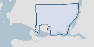
- 2007: This feature class was digitized from marked-up maps as supplied by the District of North Vancouver Fire Department. Areas where water supply is limited and or Fire response times were greater than average are identified.
Quality
- Accuracy
- Completeness
-
- Spatial information is known to be complete, expected to be complete or very close to complete.
Maintenance
The Fire department submits marked-up maps to the GIS department. Boundaries are adjusted in the GIS as required.
Supporting Documentation
- Data Dictionary
- Not Applicable
- Relationships
- Not Applicable
- Rights
- Terms and Conditions of Use